
Urbanisation and Demographics: A Story of Sri Lanka’s Cities
- November 14, 2025
- eunoialankatours
- 9:53 pm
Sri Lanka’s Urban Story: From Ancient Capitals to the Megapolis
Sri Lanka’s urban story is woven into the island’s rivers, tanks and sacred sites. When “nagara” (city) first appeared in early Brahmi inscriptions, it described settlements like Anuradhagama that combined residences, services and defences. Over time many villages merged into prosperous cities, and the idea of a Nagara System spread across the island. At its heart were water and trade: reservoirs, canals and ports that enabled farming and commerce; monasteries that attracted pilgrims and scholars; and ports that welcomed traders from Arabia, India and East Asia. From Anuradhapura to the modern Western Province megapolis, Sri Lanka’s urbanisation has been as much about culture and religion as about bricks and mortar.
Anuradhapura – the first great urban experiment
Anuradhapura was the first city to grow, and by the 4th century BCE, when King Pandukabhaya made it his capital, it had become a city. The streets were set out in a grid and built with bricks. Terra cotta pipes ran under the roads to bring in water and take out waste materials, which shows that they knew a lot about sanitation. In the 4th century CE, King Buddhadasa published Sarartha Sangraha, a book about medicine, and built hospitals. The remains between Thuparamaya and Abhayagiri show that the health system was still going strong. The Abhayagiri monastery was like a university, bringing monks and intellectuals from Kashmir to China. Anuradhapura was home to more than 8,000 monks at its height, and stupas like Ruwanwelisaya were some of the biggest buildings in the ancient world. People from India, Rome, and China worked and prayed together in the city, which was a melting pot.
The landscape of Anuradhapura was mostly water. The Nuwara Wewa, Tissa Wewa, and Abhaya Wewa reservoirs hydrated the fields and provided water to the city. The royal Ranmasu Uyana garden below Tissa Wewa had a pleasure park with ponds and fountains. Anuradhapura was a centre of trade, religion, and government because it was connected to seaports and other settlements by a network of roadways.
Sigiriya – a palace in the clouds
After taking the throne, Prince Kassapa built the Sigiriya fortress castle out of a 200-meter rock to protect himself. Archaeological evidence reveals that Sigiriya was a monastery as far back as the 3rd century BCE. There were also prehistoric towns near Pidurangala and Ibbankatuwa, which shows that hunter-gatherer, early Iron Age, and urban cultures all lived in the same area. Kassapa’s engineers created terraces, walls, and mirror-like rock faces, but the water gardens were their best work. Visitors to Sigiriya still stroll by symmetrical pools, island pavilions, and fountains. In the dry season, curved bathing pools and islands were used as palaces. The gardens were laid out in a way that the central palace was at the intersection of the north-south and east-west axes. Underground clay pipes brought water from the Sigiriya Wewa tank to fountains and ponds. This showed that the builders knew a lot about hydraulics and geometry. Senarath Paranavithana, an epigraphist, looked at graffiti left by visitors from the 6th to the 14th century. The lyrics praise the beauty of the rock art and show that the writers were well literate. Roman and Chinese coins unearthed at the site show that a cosmopolitan elite was involved in long-distance trade.
Polonnaruwa – agriculture, religion and learning
After Anuradhapura fell, royal power shifted to Polonnaruwa. Its urbanization reached its zenith in the 12th–13th centuries when kings such as Parakramabahu I and Nissanka Malla unified the island. The city stood at a strategic crossroads between the north and south, controlling routes to Rohana and Jaffna; contemporary sources call it Kandavuru Nuwara (camp city). Polonnaruwa blended religion and agriculture: there were more than sixteen Hindu shrines alongside innumerable Buddhist monasteries; the sacred Tooth Relic resided in a temple near the palace, symbolising legitimacy. The Alahana Pirivena complex served as a monastic university covering roughly 80 hectares; its terraces housed lecture halls, chapter houses and residential cells. A hospital with medicinal troughs and a network of ponds and drainage pipes reveal the care invested in public health and water management. Parakramabahu built five of the twelve major reservoirs (Wewa) recorded in Polonnaruwa, including Parakrama Samudra, under the motto “not a drop of water shall flow to the sea without being used.” These tanks irrigated fields that fed the city and supported its booming population.
Polonnaruwa’s decline was swift. The 13th-century invasion of Kalinga Maga devastated irrigation works, and by the end of the century, people migrated south-west. Subsequent capitals—Dambadeniya, Yapahuwa, Kurunegala and Gampola—were short-lived, and much of their urban fabric lies beneath later settlements.
Kotte and the colonial encounter
The 14th century saw the start of a new chapter when Nissanka Alagakkonara, a minister to King Vikramabahu III, erected a fortified city at Kotte. He built temples to the gods Upulvan, Saman, Vibishana, and Skanda, which promoted theism in a way that prior capitals had not. During the 15th century, when King Parakramabahu VI ruled, Kotte thrived. The Tooth Relic temple was built near the palace, and processions to commemorate it became the city’s most important rites.
Europeans came in the 16th century. In 1505, Portuguese ships led by Don Lourenço de Almeida came to Colombo and set up a commercial base there. But they quickly made the port stronger and got involved in local politics. King Bhuvanekabahu VII asked the Portuguese for help against his brother Mayadunne of Sitawaka. His grandson Dharmapala became a Roman Catholic in 1557. Portuguese soldiers in Kotte brought cannons and guns with them, which changed city life even further. Religious diversity changed: Buddhism and Hinduism stayed, but Catholic churches grew, and a new urban culture developed with European, South Indian, and Sinhalese elements because of to the Portuguese. After Kotte was left behind in 1565, the Portuguese took control of Colombo Fort, which is now the capital city.
Colonial and post-colonial planning
Colombo grew from a modest harbour into Sri Lanka’s main business and administrative centre while it was under Dutch and British occupation from 1658 to 1948. British town planning was mostly about sanitation and zoning. In the late 1800s, laws made housing and street layouts better. Planners like Patrick Geddes and Clifford Holliday came up with garden city and traffic plans. After gaining independence, the government tried to control the rapid growth of cities through regional planning. Abercrombie’s Regional Plan (1948) suggested building satellite towns around Colombo, and the 1978 Colombo Master Plan and the Urban Development Authority that followed it set the rules for zoning, infrastructure, and environmental management. The Western Region Megapolis Plan is one of many modern initiatives that aims to turn Colombo, Negombo, and Gampaha into one megacity by 2030. This will address issues with housing, transit, and the environment, and put Sri Lanka on the same level as major cities like Dubai and Singapore.
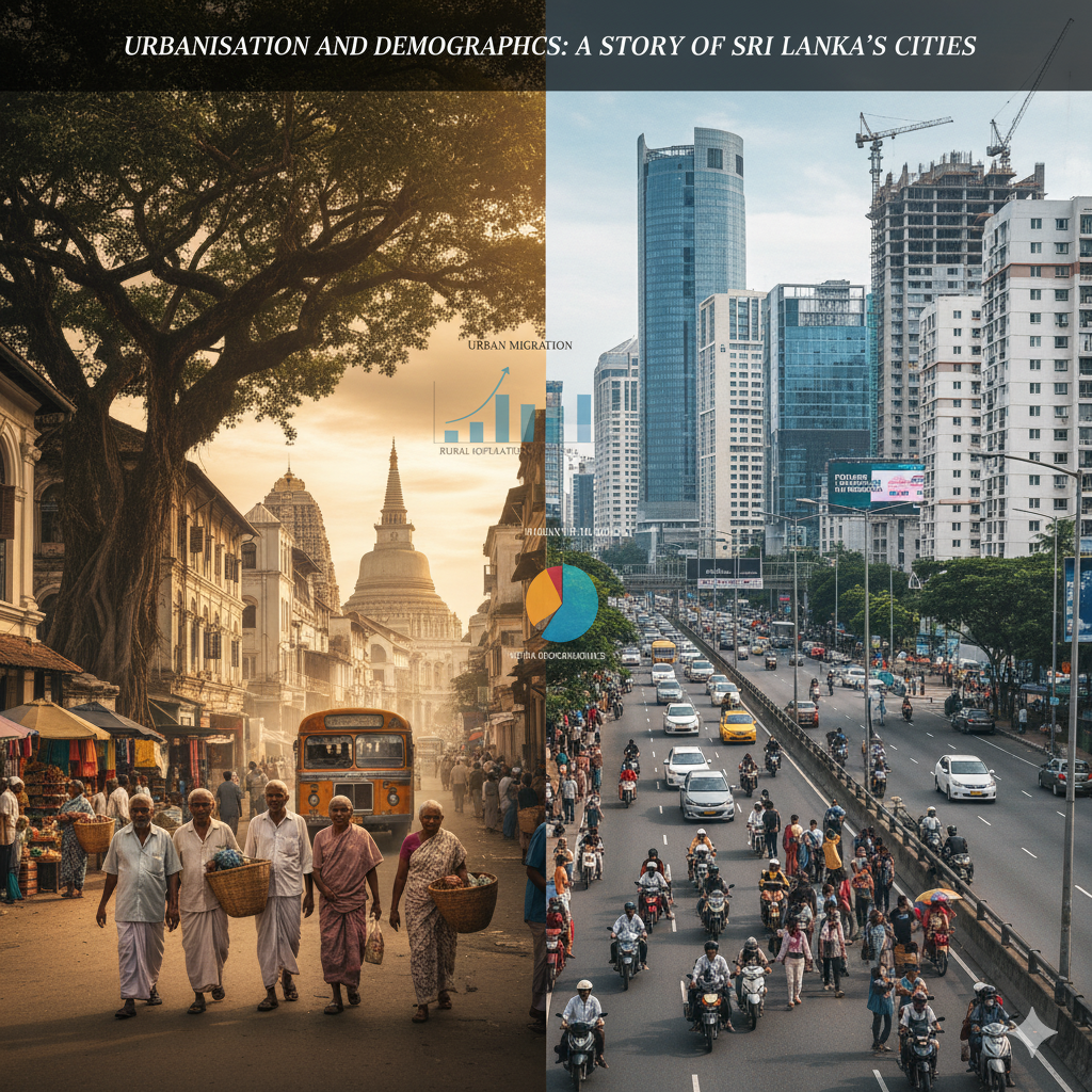
Demographics: a diverse, young and low-urbanised island
Sri Lanka’s demographic profile reflects its complex history and emerging urban challenges. According to United Nations estimates, the population in 2025 is about 23.23 million with a median age around 33 years. Population density is high—around 370 people per km$^2$—but only about 18 % of people live in urban areas, making Sri Lanka one of the least urbanised countries in Asia. This low figure partly results from narrow administrative definitions; peri-urban settlements with urban characteristics are often classified as rural. Urbanisation is increasing slowly (about 1.2 % annually), and the government’s megapolis initiatives reflect a desire to manage this growth sustainably.
Population structure and ethnic diversity
Sri Lanka’s population structure is youthful but ageing: the total dependency ratio is about 49 % with a child dependency ratio around 37 % and an aged dependency ratio of 12 %. Life expectancy at birth is 76.6 years (male $\approx$ 73.6, female $\approx$ 79.8).
Ethnically, Sinhalese make up roughly 75 % of the population, concentrated in the south-west and central regions; Sri Lankan Tamils account for about 11 % and live mainly in the north and east; Moors (descendants of Arab traders) constitute about 9 %. Buddhists represent about 70 % of the population, Hindus 12.6 %, Muslims 9.7 % and Christians (mostly Roman Catholic) about 7 %. Sinhala is spoken by around 87 %, Tamil by 28.5 % and English by 23.8 % as a link language. Literacy rates are high (over 92 %).
Districts and urban centres
| District | Population (2023, approx.) | Density (people/km$^2$) | Notes |
|---|---|---|---|
| Colombo | 2.46 million | 3,666 | Most densely populated; includes Colombo city and suburbs. |
| Gampaha | 2.421 million | 1,749 | Part of Western Province megapolis. |
| Kandy | 1.482 million | 1,112 | Hill-country capital; UNESCO heritage city. |
| Galle | 1.133 million | 808 | Southern coastal city; colonial fort. |
| Jaffna | 603,000 | 682 | Northern cultural centre; Tamil majority. |
| Nuwara Eliya | 789,000 | 500 | Tea-plantation region; highland climate. |
Colombo is still the country’s financial and administrative centre. The city itself has about 648,000 people, but the metropolitan region has more than 5.6 million, with more than 52,000 people/km$^2$. The city is home to people from many different ethnic and religious groups. About 31% of population are Muslim, 31% are Buddhist, 23% are Hindu, and 14% are Christian. The projected expansion of Colombo’s ports and airports, as well as the building of motorways and railroads to connect the city to its hinterland, shows that the capital is still very important.
Looking forward
The story of Sri Lanka’s cities is one of strength and change. Ancient cities like Anuradhapura, Sigiriya, and Polonnaruwa exemplify how people in the past harmonised their religious beliefs, their engineering skills, and their business skills. Later cities took ideas from Hinduism, South Indian dynasties, and European colonisers, creating a unique mix of urban cultures. Today, the country has to deal with the problem of how to grow while still protecting its history and the environment. About one-fifth of Sri Lankans live in officially recognised urban areas. However, peri-urban sprawl is growing, and climate change is putting coastal and low-lying villages at risk.
The Western Region Megapolis is an example of a project that wants to turn the Western Province into a sustainable, globally competitive city. But for the island to be successful, its various populations and lessons from the past must be respected in the planning process. This means using water responsibly, combining religious and cultural spaces, and making sure everyone has equal access to education and health care. When we tell this narrative for Eunoia Lanka, we remember that urbanisation isn’t just about buildings and roads; it’s also about people, beliefs, nature, and the delicate art of getting along.
This article follows the path from ancient capitals like Anuradhapura and Sigiriya to modern-day Colombo, mixing archaeological information with current population data and plans for the future of the city. It talks about how Sri Lanka’s cities were influenced by religious centres, commerce networks, colonial influences, and how today’s population structure, ethnic variety, and low level of urbanisation are. The article also talks about problems and projects related to sustainable development, like the Western Region Megapolis proposal.
Recent Posts
The Knuckles Conservation Forest – Sri Lanka’s Misty Wilderness of Dumbara
The Knuckles Conservation Forest – Sri Lanka’s Misty Wilderness of Dumbara